


Google plans to bring more updates to Google Maps later this year, including a near-realistic and immersive view of the world around it. As if filmed by a drone, users can get a comprehensive view of city details, landmarks, traffic and weather.
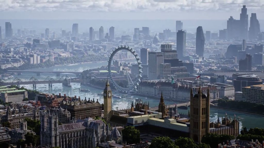
To achieve this, Google combines billions of satellite images and Street View images together, and through advances in 3D mapping and machine learning, creates a high-resolution image of a city that Google has dubbed “global view.” Using the example of London, Google showed how the map view changes from an overhead view to a bird’s eye view of the depths of the city, like a virtual drone flight. The example of Westminster in London showed that in the future Google Maps will provide a new view area in the view of the scene.
Monitor traffic and weather “live”.
In the immersive view, you can jump from one scene to the next, like Big Ben, and other details can be called up on the map, like the current traffic or weather. Using a timeline in the lower area of the screen, users can see “live” how the weather will develop over the next hours. Appropriately, Google Maps animates the sky and also shows forecast showers.
Go from the street to the restaurant
The change in buildings and restaurants is impressive. From the Street View view, the new Google Maps will be able to seamlessly switch to the interior view of a restaurant, for example (in the video from 8:50 a.m.), as if Google had flown over that place too with a drone. As Sundar Pichai, CEO of Alphabet/Google explained in the keynote, the rendering is created only from images using neural rendering. According to Google, Immersive View works on almost every smartphone and similar devices.
The immersive view will be offered first for Los Angeles, London, New York, San Francisco and Tokyo later this year. Google said other cities are being planned.
Planning climate-friendly routes for Europe
In addition, Google announced that it will also bring climate-friendly mapping in Google Maps, i.e. navigation based on the most fuel-efficient rather than the fastest, to Europe after it was already introduced in the USA and Canada. A screenshot from the Berlin region shows that Germany also means this.
Live view for developers
It is convenient for developers to provide Live View free of charge via the ARCore Geospatial API, so that third-party applications can also use the feature in the future. Live View is used in Google Maps to display useful arrows and directions directly on the screen over the real image using augmented reality. The function can be useful when navigating on foot on the street or in complex buildings such as airports, shopping malls or train stations. Live View can also be used to find a reserved seat or toilets in a stadium, or to present augmented reality-enabled games as an overlay of the real world.

“Subtly charming coffee scholar. General zombie junkie. Introvert. Alcohol nerd. Travel lover. Twitter specialist. Freelance student.”
More Stories
NASA receives the message via a laser beam from a distance of 226 million kilometers
Upgrade using 20 GPUs and 20 CPUs in testing [Update 3]
Adrenalin Edition 24.4.1: When the Manor Lords arrive tomorrow, the driver will be ready